Much conversation has centered on the concept of Collaborative Cartography and the endless possibilities it offers. Not only does the map geek community benefit but new and improved Geographical Information Systems (GIS) are exploring community-based applications that "facilitate public participation in geographic decision-making" (MacEachren, 2001). According to MacEachren entire neighborhoods are trying to coordinate and implement decisions regarding crime, fire, and flood plain areas. Collaborative Cartography methods allow everyone to be in different places at different times and still share real-time decision-making. The possibilities are unlimited, entirely different cultures can theoretically collaborate across oceans and mountains and make decisions about environment, trade, and major social issues such as religion and ethnic diversity. Though the concept sounds attractive Collaborative Cartography is not as easily achieved as one might believe. One of the central issues regarding this type of information sharing is the actual participation by the community. Community-based software relies very heavily on group effort and participation. The challenge is to first understand how to use the software and then begin collaboration. For example, one of the most challenging aspects in making a collaborative atlas that utilizes "different-place geocollaboration" (MacEachren, 2001) is not understanding the technology (nearly everyone can learn this aspect, given time) but getting individuals to actually sit down and collaborate. In my own experience, collaborative cartography worked surprisingly well. Everyone that participated in the effort really showed their ability to utilize software like Adobe Illustrator and ArcGIS is create visuals representation that explored a given theme.
As the planet becomes more and more populated it becomes increasingly obvious that there will be inevitable conflicts regarding some specific geographical region. Up and coming software like Google Earth Pro and SketchUp can be used in conjunction with collaborative cartography. For example, different ethnic groups can explore their population and mortality rates and make decisions regarding expansion or consolidation. Imagine the Israelis and the Palestinians collaborating on land rights and agricultural boundaries, think of all the lives that could be saved. If we are able to reach decisions prior to a conflict then modern computer technology has benefited humanity in ways sliced bread could only hope to. In addition to preventing human conflict, Collaborative Cartography can be used to define cultures as well. Imagine if the indigenous peoples of Australia (Aboriginals) could share information and data regarding specific locations of cultural importance and define regions of land that have been part of their heritage for a thousand years. The British peoples who control much of the Continent would be forced to recognize the lands of the aboriginal tribes because the world's modern cultures recognize map boundaries and commonly associate independence with such efforts. Australia and many, many, other countries that have assimluated indigenious peoples would theoretically be forced to recognize the independence of these tribes as small nations. In the same vein in would also be possible for certain culture who's people are scattered across the world to define a new type of nation, based on virtual-collaboration. Crazy talk, I know.
Tuesday, May 15, 2007
Mapping Nevada...Getting your Horst-Graben on!!!
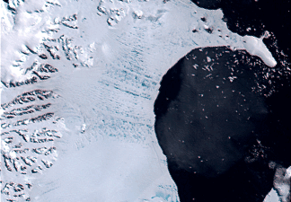
This weeks blog explores the state of Nevada and how the state is defined from a geographical perspective. There are numerous ways to define Nevada, many people know of Nevada's legendary silver mines or is cold desert environment. But how many people understand Nevada from a geographical perspective? Does Horst and Graben mean anything to you? Maybe Basin and Range? Perhaps the terms have surfaced in a converstaion and you were too embarrised to ask what horst and graben means (I understand, it does have a special tone). Fear not, in a moment you are going to learn what both these terms mean and likely a bit more too. For a college defination of Horst and Graben go to http://www.nbmg.unr.edu/comstockscience/regionalgeology4.shtml and recieve a mindful. If you are not that motivated then listen up! Nevada has a rather unique geoglogical characteristic, called Basin and Range (Horst and Graben) which refers to mountains and valley's, (this in itself is not so unique). The interesting part is that if you travel in an East or West direction you cannot help but notice that the entire drive consists of going up a mountain and across a valley, only to begin the process over when you cross the valley. Figure 2.5 clearly indicates an example of Nevada'a basin and range topography

 Google has a nice image that clearly defines a basin and range region. Figure 2.7 is an example of a horst in Nevada's East Humboldt Range.figure 2.7

Figure 2.5

Nevada's horst and graben topography is perhaps even better defined when you look at Google Earth's virtual world image (see figure 2.6)
figure 2.6
 Google has a nice image that clearly defines a basin and range region. Figure 2.7 is an example of a horst in Nevada's East Humboldt Range.
This type of geography does not occur everywhere, it is unique to a specific type of region associated with faults and earthquakes. Go to http://www.uwgb.edu/dutchs/EarthSC202Slides/eqkslide.htm for more information concerning faults and earthquakes.
The Nevada's Basin and Range are unique to the area and is the only state (correct me if I am wrong) that is almost entirely a Basin and Range environment. So take a moment and consider your next vacation, perhaps a trip to Nevada is just what the doctor ordered to get your horst graben on.
Virtual Worlds
The use of virtual world technology has increased ten-fold in the last couple of years. As data and technological advancements increase the type and complexity of virtual worlds becomes dramatically apparent. While watching a recent Law and Order episode I noticed that virtual world technology is now being used more often on television as well.
To make a long story short, the episode had a part where the detectives were using Google Earth technology to show a particular location, this in itself is very advanced technology but fairly common place these days. What struck me as interesting is when the computer images which happen to be pinpointing a criminals house from the sky, zoomed in so close you could clearly see a three dimensional building-similar to what you might see using SketchUp technology. For those of you that have never heard of SketchUp it is a very useful program that allows you to build 3D images (usually of structures) and apply them to a 2D map. Having used the both programs I know for a fact that you cannot get on Google Earth and zoom in to a 3D image so quickly. The image has to be built (using SketchUp) then added to the GE. The idea here is that as cool as it looked on T.V. the average map geek might mistakenly believe that this type of technology readily exists. The increasingly advanced mapping technology has created a special niche in the computer industry. Map geeks are raking in the money right now because technological advancements out pace consumer ability to comprehend the virtual world application technology.
For me one of the most exciting applications for Virtual World technologies is not found in a video games or television but in real-time and space. For example, scientists are using this technology to monitor Earth's volcanoes and faults. Figure 2.4 is an image that does just that, monitor Earth's volcanoes and tectonic activity
figure 2.4

Go to http://hsv.com/scitech/earthsci/quake.htm for a great example of how this technology is being utilized. Think of the possibilities? If we could build virtual worlds that are based on real-time we might be able to save millions of lives every year. Think of the applications, you could monitor tornadoes, hurricanes, and global weather patterns with the click of a button.
At first there does not seem to be any draw backs to virtual world technology but if you look closely for example at how this type of technology is being applied you might find reason to pause. First, I have heard a fair number of individuals complain that Big Brother is going to use the technology to watch our every move and I cannot disagree. Our paranoid state of reason has allowed mass hysteria to develop into the perception that everyone that is not like us is against us and should be watched closely. Second, the way this technology is presented in arenas like television is a bit misleading. It take some time to build a three-dimensional image of a house and transfer that image to a virtual map like GE.
The applications for this type of technology is endless and is only limited by our imaginations, with time and training we (human race) might one day have the ability to zoom in on our own house and see ourselves watching ourselves (Strange, but true).
Very 'Spatial' Games
This weeks blog looks at the use of spatial games and how they might be used to expand geographical knowledge. There are a number of games that utilize maps as part of a game but were did this idea originate? What culture fisrt thought of incorporating a map element into a game ? The question is a trick, no one really knows which culture first incoprorated maps into their games. According to Elloitt Avedon determining the exact origin of map games as well as any game for that matter for more details go to http://www.gamesmuseum.uwaterloo.ca/About%20Games/origins.htm
and see what Elloitt has to say about games and their orgins.
In terms of modern gaming nearly every game now incorporates a map element of some type. Some really good map-based games can be found at http://www.mywonderfulworld.org/toolsforadventure/games/index.html
These particular games utilize various aspects of a map such a direction and location and help develop basic map reading skills.
One of my favorite map-based games is a popular U.K. game called Hapland. There are three series of games that increase in difficulty as you advance. The principle idea of the game is to explore your environment and try to figure out how to get your stick figure to interact with the environment so accomplish a particular task (which remains unknown until you finish the puzzle). For lots Hapland fun go to: http://www.foon.co.uk/farcade/hapland/ and see if you can meet the challenge.
One of the best aspects of interactive map-based games is that they force the user to develop mental analysis tools that solve particular tasks. The use of interactive maps fundamenatally utilizes our natural urge to explore the unknown and rashionalize time and space.
Subscribe to:
Comments (Atom)


