Wednesday, April 25, 2007

Atlas Geek part II


Last week I ranted about what I thought was a poor idea for a children's atlas. In particular those that have religious intonations. This week I want to focus on a couple of types of geographical information that might help interest children to focus in on particular aspects of our environment. These relevant geographical events might consist of the peoples, species, and environments that make up a particular region. Impact and relevance on younger children such as those in the K-4 grade range would have to depend on presentation and design. Today's fourth grader's are expected to meet a standard higher then what was expected ten years ago. Children today operate computers with uncanny ease and are able to text message faster then you can spell yo-yo. Considering the advanced if somewhat uncanny abilities of younger children it is apparent that an atlas has to be able to keep their attention and express information that can be absorbed rapidly. Young kids are often treated like children but expected to learn like adults. A child's atlas covers a wide range of subjects some of which are a bit surprising. For example, Canada has an atlas that emphasizes regions of the country from the perspective of environment seen in figure 2.1. This type of atlas focuses on human interactions with Earth's environment. Using specific elements like the Moose and Bear to draw a child's attention and get them to remember location and range of animal species particular to a region.

figure 2.1

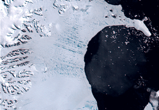
Other aspects of the environment that children remember are those that are extreme. Such as that seen in figure 2.2. Glacial ice is a major part of Earth's environment and covers nearly a third of the planet. Such major events are not only fascinating but important to understand as Earth's atmosphere continues to warm defying the natural cooling cycle.


figure 2.2
Also becoming increasingly popular is the concept of the universe and our place within the galaxy. Modern children are expected to explore well beyond the realm of Earth. Understanding the Universe and how it operates boggles most adults yet our children are expected to understand modern ideas concerning space exploration. Figure 2.3 is just one example of such an atlas.

figure 2.3
The average map geek is not being created in college or even in high school, instead they seem to be sprouting map geeks in kinder garden. Keeping up with advancements in education is challenging and often stumps adults but today's children are not stumped by this movement rather they embrace this new information and use it in ways I never thought possible as a child. Making Earth's human populations conscious of their interaction with the environment is as important as ever and increasingly so as humans just about destroy everything they touch.

Sunday, April 15, 2007

How a map geek is created- A Childern's Atlas Part I

For years now I have focused on maps, maps of every type and variety not once thinking how did I get to be a map geek. How does a map geek get to be a geek? where we born that way? likely not, but perhaps we were exposed to a really cool atlas when they were young and have been lost in the world of map geeks ever since. This is my angle, a good children's atlas can make all the difference in the world between a real map geek and a the 'other'. Let's take a moment and consider a few aspects of becoming a map geek.
There are many things to consider when it comes to a childern's atlas. First, what age is the best to begin teaching childern about their world? What do you show them? How will they understand what they see? How will the young map geek transform information from a book into real-world applications.
Interest in physical surroundings and their location on the planet seems to become an active quest when a child is around 7-8 years old, judging from my own experience of course. Therefore creating a children's atlas should begin with the basics such as the Geography of our environment, and all organic species living on the planet. These are just a few of the major themes that should be considered. There are a few things that I feel should not be part of a children's atlas. In my opinion, this would be anything religious in any tone or form. Several childern's biblicial atlas's that I have viewed all seem to start with the same theme that to me shows signs of creating social lines based on religious views of the world. Here is an example, I just don't see how this type of geographic information can help a six-year old learn or want to learn more about their surroundings.

I' m not saying that this is not important information or anything it just is not a proper formula to begin teaching childern geography of the world.
Please join me next week for part two when we take a closer look at why it's important to begin teaching childern about their local environment first rather then far off lands. Until then-geek on!


Wednesday, April 4, 2007

Extreme Cartography

This weeks blog attempts to isolate the concept of Extreme Cartography. There are a wide range of ideas regarding what Extreme means. For some it indicates geographical areas that are isolated from the average individual such as Antarctica. For others, it surfaces as a form of social interaction such as extreme political and religious groups. For me extreme cartography has nothing to do with our planet. For the most part nearly everything on the planet can be mapped in some way except perhaps the interior of the planet which the Japanese are attempting to crack as I write. Cartography of the universe seems to fall neatly into the slot of extreme. there are a number of scientists today that are focusing on building a map of our galaxy and all the surrounding galaxy's as well. In an attempt to figure out what the most abundant substance in the universe is (dark energy) and how if works a good article to begin this discussion can be found at http://www.newscientist.com/article.ns?id=dn4314 this article is a few years old but still relevant to extreme cartography. In terms of astrophysics there is a man named Gott, Juric et al that has constructed a logarithmic map of the universe http://www.astro.princeton.edu/~mjuric/universe/ This site offers a nice maps of the entire perceived universe, galaxy and solar system near earth. You should definitely check out this site if you are interested in "the final frontier" (William Shattner, original Star Trek).


The following maps indicates why scientists believe that dark energy is the dominate material of our universe, for a great explanation of this map go to
their web site at antwrp.gsfc.nasa.gov/apod/ap031028.html


The map below is a map that attempts to define the BIG BANG theory and actually makes a lot of sense for further information regarding this concept go to

del.icio.us/nikomicapero/timeline

Mapping the universe is challenging as many features cannot be physically interacted with. Developing a map under these conditions is definably EXTREME! Map geeks be alert as new information regarding the universe is discovered every day and a Extreme map is sure to follow.