Much conversation has centered on the concept of Collaborative Cartography and the endless possibilities it offers. Not only does the map geek community benefit but new and improved Geographical Information Systems (GIS) are exploring community-based applications that "facilitate public participation in geographic decision-making" (MacEachren, 2001). According to MacEachren entire neighborhoods are trying to coordinate and implement decisions regarding crime, fire, and flood plain areas. Collaborative Cartography methods allow everyone to be in different places at different times and still share real-time decision-making. The possibilities are unlimited, entirely different cultures can theoretically collaborate across oceans and mountains and make decisions about environment, trade, and major social issues such as religion and ethnic diversity. Though the concept sounds attractive Collaborative Cartography is not as easily achieved as one might believe. One of the central issues regarding this type of information sharing is the actual participation by the community. Community-based software relies very heavily on group effort and participation. The challenge is to first understand how to use the software and then begin collaboration. For example, one of the most challenging aspects in making a collaborative atlas that utilizes "different-place geocollaboration" (MacEachren, 2001) is not understanding the technology (nearly everyone can learn this aspect, given time) but getting individuals to actually sit down and collaborate. In my own experience, collaborative cartography worked surprisingly well. Everyone that participated in the effort really showed their ability to utilize software like Adobe Illustrator and ArcGIS is create visuals representation that explored a given theme.
As the planet becomes more and more populated it becomes increasingly obvious that there will be inevitable conflicts regarding some specific geographical region. Up and coming software like Google Earth Pro and SketchUp can be used in conjunction with collaborative cartography. For example, different ethnic groups can explore their population and mortality rates and make decisions regarding expansion or consolidation. Imagine the Israelis and the Palestinians collaborating on land rights and agricultural boundaries, think of all the lives that could be saved. If we are able to reach decisions prior to a conflict then modern computer technology has benefited humanity in ways sliced bread could only hope to. In addition to preventing human conflict, Collaborative Cartography can be used to define cultures as well. Imagine if the indigenous peoples of Australia (Aboriginals) could share information and data regarding specific locations of cultural importance and define regions of land that have been part of their heritage for a thousand years. The British peoples who control much of the Continent would be forced to recognize the lands of the aboriginal tribes because the world's modern cultures recognize map boundaries and commonly associate independence with such efforts. Australia and many, many, other countries that have assimluated indigenious peoples would theoretically be forced to recognize the independence of these tribes as small nations. In the same vein in would also be possible for certain culture who's people are scattered across the world to define a new type of nation, based on virtual-collaboration. Crazy talk, I know.
Tuesday, May 15, 2007
Mapping Nevada...Getting your Horst-Graben on!!!
This weeks blog explores the state of Nevada and how the state is defined from a geographical perspective. There are numerous ways to define Nevada, many people know of Nevada's legendary silver mines or is cold desert environment. But how many people understand Nevada from a geographical perspective? Does Horst and Graben mean anything to you? Maybe Basin and Range? Perhaps the terms have surfaced in a converstaion and you were too embarrised to ask what horst and graben means (I understand, it does have a special tone). Fear not, in a moment you are going to learn what both these terms mean and likely a bit more too. For a college defination of Horst and Graben go to http://www.nbmg.unr.edu/comstockscience/regionalgeology4.shtml and recieve a mindful. If you are not that motivated then listen up! Nevada has a rather unique geoglogical characteristic, called Basin and Range (Horst and Graben) which refers to mountains and valley's, (this in itself is not so unique). The interesting part is that if you travel in an East or West direction you cannot help but notice that the entire drive consists of going up a mountain and across a valley, only to begin the process over when you cross the valley. Figure 2.5 clearly indicates an example of Nevada'a basin and range topography

 Google has a nice image that clearly defines a basin and range region. Figure 2.7 is an example of a horst in Nevada's East Humboldt Range.figure 2.7

Figure 2.5

Nevada's horst and graben topography is perhaps even better defined when you look at Google Earth's virtual world image (see figure 2.6)
figure 2.6
 Google has a nice image that clearly defines a basin and range region. Figure 2.7 is an example of a horst in Nevada's East Humboldt Range.
This type of geography does not occur everywhere, it is unique to a specific type of region associated with faults and earthquakes. Go to http://www.uwgb.edu/dutchs/EarthSC202Slides/eqkslide.htm for more information concerning faults and earthquakes.
The Nevada's Basin and Range are unique to the area and is the only state (correct me if I am wrong) that is almost entirely a Basin and Range environment. So take a moment and consider your next vacation, perhaps a trip to Nevada is just what the doctor ordered to get your horst graben on.
Virtual Worlds
The use of virtual world technology has increased ten-fold in the last couple of years. As data and technological advancements increase the type and complexity of virtual worlds becomes dramatically apparent. While watching a recent Law and Order episode I noticed that virtual world technology is now being used more often on television as well.
To make a long story short, the episode had a part where the detectives were using Google Earth technology to show a particular location, this in itself is very advanced technology but fairly common place these days. What struck me as interesting is when the computer images which happen to be pinpointing a criminals house from the sky, zoomed in so close you could clearly see a three dimensional building-similar to what you might see using SketchUp technology. For those of you that have never heard of SketchUp it is a very useful program that allows you to build 3D images (usually of structures) and apply them to a 2D map. Having used the both programs I know for a fact that you cannot get on Google Earth and zoom in to a 3D image so quickly. The image has to be built (using SketchUp) then added to the GE. The idea here is that as cool as it looked on T.V. the average map geek might mistakenly believe that this type of technology readily exists. The increasingly advanced mapping technology has created a special niche in the computer industry. Map geeks are raking in the money right now because technological advancements out pace consumer ability to comprehend the virtual world application technology.
For me one of the most exciting applications for Virtual World technologies is not found in a video games or television but in real-time and space. For example, scientists are using this technology to monitor Earth's volcanoes and faults. Figure 2.4 is an image that does just that, monitor Earth's volcanoes and tectonic activity
figure 2.4

Go to http://hsv.com/scitech/earthsci/quake.htm for a great example of how this technology is being utilized. Think of the possibilities? If we could build virtual worlds that are based on real-time we might be able to save millions of lives every year. Think of the applications, you could monitor tornadoes, hurricanes, and global weather patterns with the click of a button.
At first there does not seem to be any draw backs to virtual world technology but if you look closely for example at how this type of technology is being applied you might find reason to pause. First, I have heard a fair number of individuals complain that Big Brother is going to use the technology to watch our every move and I cannot disagree. Our paranoid state of reason has allowed mass hysteria to develop into the perception that everyone that is not like us is against us and should be watched closely. Second, the way this technology is presented in arenas like television is a bit misleading. It take some time to build a three-dimensional image of a house and transfer that image to a virtual map like GE.
The applications for this type of technology is endless and is only limited by our imaginations, with time and training we (human race) might one day have the ability to zoom in on our own house and see ourselves watching ourselves (Strange, but true).
Very 'Spatial' Games
This weeks blog looks at the use of spatial games and how they might be used to expand geographical knowledge. There are a number of games that utilize maps as part of a game but were did this idea originate? What culture fisrt thought of incorporating a map element into a game ? The question is a trick, no one really knows which culture first incoprorated maps into their games. According to Elloitt Avedon determining the exact origin of map games as well as any game for that matter for more details go to http://www.gamesmuseum.uwaterloo.ca/About%20Games/origins.htm
and see what Elloitt has to say about games and their orgins.
In terms of modern gaming nearly every game now incorporates a map element of some type. Some really good map-based games can be found at http://www.mywonderfulworld.org/toolsforadventure/games/index.html
These particular games utilize various aspects of a map such a direction and location and help develop basic map reading skills.
One of my favorite map-based games is a popular U.K. game called Hapland. There are three series of games that increase in difficulty as you advance. The principle idea of the game is to explore your environment and try to figure out how to get your stick figure to interact with the environment so accomplish a particular task (which remains unknown until you finish the puzzle). For lots Hapland fun go to: http://www.foon.co.uk/farcade/hapland/ and see if you can meet the challenge.
One of the best aspects of interactive map-based games is that they force the user to develop mental analysis tools that solve particular tasks. The use of interactive maps fundamenatally utilizes our natural urge to explore the unknown and rashionalize time and space.
Wednesday, April 25, 2007
Atlas Geek part II
Last week I ranted about what I thought was a poor idea for a children's atlas. In particular those that have religious intonations. This week I want to focus on a couple of types of geographical information that might help interest children to focus in on particular aspects of our environment. These relevant geographical events might consist of the peoples, species, and environments that make up a particular region. Impact and relevance on younger children such as those in the K-4 grade range would have to depend on presentation and design. Today's fourth grader's are expected to meet a standard higher then what was expected ten years ago. Children today operate computers with uncanny ease and are able to text message faster then you can spell yo-yo. Considering the advanced if somewhat uncanny abilities of younger children it is apparent that an atlas has to be able to keep their attention and express information that can be absorbed rapidly. Young kids are often treated like children but expected to learn like adults. A child's atlas covers a wide range of subjects some of which are a bit surprising. For example, Canada has an atlas that emphasizes regions of the country from the perspective of environment seen in figure 2.1. This type of atlas focuses on human interactions with Earth's environment. Using specific elements like the Moose and Bear to draw a child's attention and get them to remember location and range of animal species particular to a region.
figure 2.1

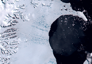
Other aspects of the environment that children remember are those that are extreme. Such as that seen in figure 2.2. Glacial ice is a major part of Earth's environment and covers nearly a third of the planet. Such major events are not only fascinating but important to understand as Earth's atmosphere continues to warm defying the natural cooling cycle.
figure 2.2

Also becoming increasingly popular is the concept of the universe and our place within the galaxy. Modern children are expected to explore well beyond the realm of Earth. Understanding the Universe and how it operates boggles most adults yet our children are expected to understand modern ideas concerning space exploration. Figure 2.3 is just one example of such an atlas.
figure 2.3

The average map geek is not being created in college or even in high school, instead they seem to be sprouting map geeks in kinder garden. Keeping up with advancements in education is challenging and often stumps adults but today's children are not stumped by this movement rather they embrace this new information and use it in ways I never thought possible as a child. Making Earth's human populations conscious of their interaction with the environment is as important as ever and increasingly so as humans just about destroy everything they touch.
Sunday, April 15, 2007
How a map geek is created- A Childern's Atlas Part I
For years now I have focused on maps, maps of every type and variety not once thinking how did I get to be a map geek. How does a map geek get to be a geek? where we born that way? likely not, but perhaps we were exposed to a really cool atlas when they were young and have been lost in the world of map geeks ever since. This is my angle, a good children's atlas can make all the difference in the world between a real map geek and a the 'other'. Let's take a moment and consider a few aspects of becoming a map geek.
There are many things to consider when it comes to a childern's atlas. First, what age is the best to begin teaching childern about their world? What do you show them? How will they understand what they see? How will the young map geek transform information from a book into real-world applications.
Interest in physical surroundings and their location on the planet seems to become an active quest when a child is around 7-8 years old, judging from my own experience of course. Therefore creating a children's atlas should begin with the basics such as the Geography of our environment, and all organic species living on the planet. These are just a few of the major themes that should be considered. There are a few things that I feel should not be part of a children's atlas. In my opinion, this would be anything religious in any tone or form. Several childern's biblicial atlas's that I have viewed all seem to start with the same theme that to me shows signs of creating social lines based on religious views of the world. Here is an example, I just don't see how this type of geographic information can help a six-year old learn or want to learn more about their surroundings.

I' m not saying that this is not important information or anything it just is not a proper formula to begin teaching childern geography of the world.
Please join me next week for part two when we take a closer look at why it's important to begin teaching childern about their local environment first rather then far off lands. Until then-geek on!
Wednesday, April 4, 2007
Extreme Cartography
This weeks blog attempts to isolate the concept of Extreme Cartography. There are a wide range of ideas regarding what Extreme means. For some it indicates geographical areas that are isolated from the average individual such as Antarctica. For others, it surfaces as a form of social interaction such as extreme political and religious groups. For me extreme cartography has nothing to do with our planet. For the most part nearly everything on the planet can be mapped in some way except perhaps the interior of the planet which the Japanese are attempting to crack as I write. Cartography of the universe seems to fall neatly into the slot of extreme. there are a number of scientists today that are focusing on building a map of our galaxy and all the surrounding galaxy's as well. In an attempt to figure out what the most abundant substance in the universe is (dark energy) and how if works a good article to begin this discussion can be found at http://www.newscientist.com/article.ns?id=dn4314 this article is a few years old but still relevant to extreme cartography. In terms of astrophysics there is a man named Gott, Juric et al that has constructed a logarithmic map of the universe http://www.astro.princeton.edu/~mjuric/universe/ This site offers a nice maps of the entire perceived universe, galaxy and solar system near earth. You should definitely check out this site if you are interested in "the final frontier" (William Shattner, original Star Trek).

The following maps indicates why scientists believe that dark energy is the dominate material of our universe, for a great explanation of this map go to
their web site at antwrp.gsfc.nasa.gov/apod/ap031028.html

Mapping the universe is challenging as many features cannot be physically interacted with. Developing a map under these conditions is definably EXTREME! Map geeks be alert as new information regarding the universe is discovered every day and a Extreme map is sure to follow.

The following maps indicates why scientists believe that dark energy is the dominate material of our universe, for a great explanation of this map go to
their web site at antwrp.gsfc.nasa.gov/apod/ap031028.html
The map below is a map that attempts to define the BIG BANG theory and actually makes a lot of sense for further information regarding this concept go to
del.icio.us/nikomicapero/timeline
Mapping the universe is challenging as many features cannot be physically interacted with. Developing a map under these conditions is definably EXTREME! Map geeks be alert as new information regarding the universe is discovered every day and a Extreme map is sure to follow.
Saturday, March 24, 2007
Mapping Technology
Mapping technology has benefited greatly from the rise of computers. Traditionally maps were composed using a great deal of ink, elbow grease, and of course imagination. Contemporary maps are much easier to make because the hard work has been done for us, we don't need to figure out a system like longitude/latitude or UTM to accurately plot random locations on the planet. We don't even require much map making knowledge or skill to produce a map a computer will gladly accommodate. This weeks blog takes a look at applications for maps that entail more then a hike to the summit. Maps that save lives by help humans better understand their environment. After all, is not a map a Homosapien's representation of time and space? Today's mapping technology has many applications and one of the most current is known as LandScan http://www.ornl.gov/sci/landscan/and was used to help rescuers determine the location of the 2004 tsunami survivors. LandScan was developed by the United States military and is attributed to saving thousands of lives when natural disasters occur. You can find a great NPR article at http://www.npr.org/templates/story/story.php?storyId=4250296 that provides better detail regarding this type of mapping technology.
One of the latest trends in mapping technology involves mobile mapping. http://holtz.org/Library/Mobile/Maps/ One common example of a mobile mapping technology is used by Google Earth, a popular user friendly mapping technology that combines traditional mapping methods with modern contemporary computer technology. Mobile mapping technology such as Google Earth can be installed in a cellphone, PDA, Laptop, and Ipod and offers users instant access to all types of maps such as road atlases. Each of these devices have the potential to utilize GIS information and process it as an image such as a map of your favorite park or freeway. Using this technology can help you avoid traffic jams and other hazardous situations. You can track dangerous criminals like those marijuana smokers, and you can keep an eye on local weather conditions to better prepare yourself.

mobile image of hurricane surge 1999.
Traditionally, GIS programming relied on a static environment, mobile devices such as cell phones require a different type of GIS language to transfer information to a roving device. The following web site http://www.gisdevelopment.net/technology/mobilemapping/index.htm offers some great articles written by the developers of the mobile programming language, definitely worth a look.
Mapping technology is only beginning to see its full potential. Scientists are using modern mapping techniques to track global warming trends, earthquakes, and virtually any other environmental system you can imagine. So take a moment and read up because soon all human kind will be taken over by hordes of map geeks.
Wednesday, March 21, 2007
3D Catrography
This weeks blog looks at cartography and three-dimensional maps. How does a cartographer depict 3D images on a two-dimensional piece of paper? A web-site maintained by the Three-Dimensional Geologic Maps and Visualization Project http://geology.wr.usgs.gov/wgmt/3d/
focuses on using three-dimensional maps that use traditional geologic information in conjunction with contemporary computer mapping techniques. Figure 2.1 is an example of a three-dimensional map developed during this project. The addition of multiple layers does not mean that additional colors have to be used to represent the new layers. In fact, the effect is quite desirable as you now have an image that displays the depth and width of a specific geological zone.
Figure 2.1

Traditional mapping techniques have almost always attempted to incorporate the 'real world' in their maps using items like contour lines to represent elevational differences. Figure 2.2 illustrates this common technique.
Figure 2.2
Contemporary cartography continues to use traditional mapping techniques to create maps for visual use. Computers and mapping programs now allow cartographers to create maps that display the 'real world' in a different way. For example, Astronomers at the University of London have recently created a colossal three-dimensional map that is the largest of its kind. The map displays millions of galaxies spread over approximately five-million light years of space. The project is very interesting and deserves a look
http://www.ucl.ac.uk/news/news-articles/0605/06051802
Three-dimensional cartography goes way beyond making a better geological map or developing maps that explore the universe. Today's cartographers are building maps for areas of the 'real world' only imagined until now. The medical industry, nano-physics, and other areas of study have been given a new perspective on traditional concepts. Modern cartography's expansion to realms other then geop has opened doors so vast that there is now an overwhelming demand for computer savvy map geeks like us. Finally we get paid to do what we like the most, develop, analyze, and critize maps.
focuses on using three-dimensional maps that use traditional geologic information in conjunction with contemporary computer mapping techniques. Figure 2.1 is an example of a three-dimensional map developed during this project. The addition of multiple layers does not mean that additional colors have to be used to represent the new layers. In fact, the effect is quite desirable as you now have an image that displays the depth and width of a specific geological zone.
Figure 2.1

Traditional mapping techniques have almost always attempted to incorporate the 'real world' in their maps using items like contour lines to represent elevational differences. Figure 2.2 illustrates this common technique.
Figure 2.2

Contemporary cartography continues to use traditional mapping techniques to create maps for visual use. Computers and mapping programs now allow cartographers to create maps that display the 'real world' in a different way. For example, Astronomers at the University of London have recently created a colossal three-dimensional map that is the largest of its kind. The map displays millions of galaxies spread over approximately five-million light years of space. The project is very interesting and deserves a look
http://www.ucl.ac.uk/news/news-articles/0605/06051802
Three-dimensional cartography goes way beyond making a better geological map or developing maps that explore the universe. Today's cartographers are building maps for areas of the 'real world' only imagined until now. The medical industry, nano-physics, and other areas of study have been given a new perspective on traditional concepts. Modern cartography's expansion to realms other then geop has opened doors so vast that there is now an overwhelming demand for computer savvy map geeks like us. Finally we get paid to do what we like the most, develop, analyze, and critize maps.
Sunday, March 4, 2007
Caricature maps and contemporary cartography
This weeks post considers social idea's regarding old maps and new maps. This concept though simple in design is deceptively misleading. What makes a map old and why is it different then a new map? Are old maps old ideas about social ideology? Such as racial divisions or two dimensional representations of geographical characteristics that have since been updated by science? Armed with these basic representations of what a map could be in terms of social function let us explore the differences between old and new maps. Old maps can in some cases be thought of as representing ideas about a culture or a set of cultures that live within and are influenced their geographical region. Figure 1.7 illustrates Homer's concept of the world around 900 BCE. Greatly influenced by geography and early social ideas, early maps depicted the 'world' as being very small, flat, and trapped in a sphere.
Figure 1.7

Later period maps sometimes focused on the location of specific regions and seem to be greatly influenced by organized religion. Figure 1.8 is an example of map design that is based on the final destination of Noah's Ark.
New maps unlike old maps are often considered free from the influence of religion and social ideas. Modern cartographers are suppose to create maps that depict the world in a see-it-like-it-is manner. Do they? can modern cartography really escape the influence of government or the iconic impression of piety to culture. Figure 1.9 is one example of Germany's many propaganda maps. Throughout WWII Germany created many such maps in an attempt to scared the enemy and comfort German citizens. Cartographers in some cases are socially forced to contrive maps that misrepresent the truth as in the German example.
Figure 1.8

New maps and by new I mean maps that have been created in the last 20 years continue to suffer human ethnocentrism but to a different degree. Modern maps are very accessible in terms of production nearly anyone can create a map using computer mapping software. As a result the average map user must be weary about how information is presented or misrepresented. For example, the current president's fear based idea that claim that Iraq has numerous Weapons of Mass Destruction. Map after map was produced to support the claim. Figure 1.10 is one of dozens of propaganda maps created to secure public support for military invasion. Later reports indicate that there were no Weapon of Mass Destruction and that there probably never was. The use of maps have been an essential part of human life ways. As technology advances so do the complexities of maps and the ability to create caricature images that promote self-interest groups. The only weapon against such maliace deeds is to teach ourselves more about maps, their production, and intent.
Figure 1.9

Figure 1.10

Figure 1.7
Later period maps sometimes focused on the location of specific regions and seem to be greatly influenced by organized religion. Figure 1.8 is an example of map design that is based on the final destination of Noah's Ark.
New maps unlike old maps are often considered free from the influence of religion and social ideas. Modern cartographers are suppose to create maps that depict the world in a see-it-like-it-is manner. Do they? can modern cartography really escape the influence of government or the iconic impression of piety to culture. Figure 1.9 is one example of Germany's many propaganda maps. Throughout WWII Germany created many such maps in an attempt to scared the enemy and comfort German citizens. Cartographers in some cases are socially forced to contrive maps that misrepresent the truth as in the German example.
Figure 1.8

New maps and by new I mean maps that have been created in the last 20 years continue to suffer human ethnocentrism but to a different degree. Modern maps are very accessible in terms of production nearly anyone can create a map using computer mapping software. As a result the average map user must be weary about how information is presented or misrepresented. For example, the current president's fear based idea that claim that Iraq has numerous Weapons of Mass Destruction. Map after map was produced to support the claim. Figure 1.10 is one of dozens of propaganda maps created to secure public support for military invasion. Later reports indicate that there were no Weapon of Mass Destruction and that there probably never was. The use of maps have been an essential part of human life ways. As technology advances so do the complexities of maps and the ability to create caricature images that promote self-interest groups. The only weapon against such maliace deeds is to teach ourselves more about maps, their production, and intent.
Figure 1.9

Figure 1.10

Saturday, February 24, 2007
Maps and the News
SVS Animation 3338 - Tropospheric Ozone Impacts Global Climate Warming
This weeks blog focuses on maps and their use in world events, better known as the news. No matter where you go for a dose of the news you will notice an increase mapped images. A recent trend among news papers and television news broadcasts is the use of maps to support information. Maps have always been used to depict our geographical world in a compact and easy-to-understand piece of paper but current trends in news reporting have created an employment nitch for professional cartographers. The use of maps in everyday news reports not only helps support a reporters view point, it examines the report in a fundamentally different fashion. The above link (tropospheric Ozone Impacts) takes you to a site that has complied information over a 100 year period and presented it through a map. It's a fair to say that most people have heard about global warming at one point or another in the news. The map in this link depicts global warming like no news report could ever hope to-check it out, you'll be amazed.
The following site http://www.newseum.org/todaysfrontpages/flash/ attempts to take cartography to another level in terms of maps and the news. This site allows you to visit nearly every major news paper publication in the world from the comfort of your computer. Using a world map, all the major newspapers are represented like attributes, when you click on an attribute it opens the local news paper and you are allowed read the frontpage articles if you like what your reading there's a link that takes you to the newspapers website. This site is so cool I've given it a perminate spot in my links list.
Saturday, February 17, 2007
Interactive and animated map use
Interactive and animated maps are rising in popularity among cartographers and novice map makers, surprising misrepresentations can surface with improper use of animation. Following the idea of Map fact, Map fiction blog I thought it might be nice to look at a scholarly article that talks about a very important element in maps, the legend. Nearly anyone who analyzes a map is forced to look at the legend for needed information. The importance of good a animated/interactive legend can make all the difference in the world. According to Menno-Jan Kraak, Rob Edsall, and Alan M. MacEachren at Pennsylvania State University "choices among them [legends] should be made with regard to the nature of the temporal data" (Menno-Jan Kraak, Rob Edsall, and Alan M. MacEachren, 2002). Too many map makers are creating interactive map legends that misrepresent the maps data. Take a look at the article link "interactive and animated legend use" at the top of the page. It provides a great deal of information regarding proper legend use and a test to help you determine if the choices you make best represent the data in your maps. I've also included a few interactive map sites to my links list that might provide further knowledge on the matter, check them out if you get a chance I think they are pretty cool. I have also found a cool article http://www-psych.stanford.edu/~bt/diagrams/papers/tversky_betrancourt.pdf that talks about the ability of maps to display animation and not violate the "Apprehension Principle" (Mireille Betrancourt, 2002).
Sunday, February 11, 2007
Maps and the American identity

My blog entry this week entails a look at maps and the American identity. There are a number of cultural markers that make us 'American' such as Baseball or perhaps a cheeseburger some have even claimed that our attitude is unique among the worlds people. For me, to think about what it means to be American reminds me of something my grandfather who was full blooded Yaqui Indian said me once, “to be an American means to live in a land built on the backs of African slaves wading through the blood of its native peoples”. I don’t know where he heard it but it has always stuck with me. After a bit of research I discovered a couple of cool maps, the first is a map that depicts the Yaqui people and their native lands the other (figure 1.5) uses current Native American census information to create a map that relies heavily on Hue but remains effective. The over all design of this map is clean despite its many colors. Ideally, a professional cartographer would use between 3-7 different colors, any more then this often leads to confusion. Can we trust this map? According to this map native peoples are doing well as they seem to cover the entire map, obviously a map like this has great potential to lie. Perhaps not on purpose but all the same, how statistical information is represented can easily be manipulated and a map such as this is a prime example of information that seems a bit skewed. I have created a link to this site, organized by the Census Scope, for those of you who would like a more in-depth look.
Figure 1.5
Figure 1.5

Sunday, February 4, 2007
Map Fact and Fiction
Factual and Fictional Maps
This week’s blog pertains to maps based in fact and or fiction. A fair number of flat maps based in fact are in actuality ‘fictional’ as they cannot represent all five mapping components (distance, direction, shape, area, and proximity). For example, figure 1.3 is a map of the island of Maui one of the islands of the Hawaii chain. This map is a good factual map as it represents several of the standard elements a flat map should have in its over all design and content. The Maui map gives the reader a basic idea of the shape and area of the island. Color is also used to represent not only elevation but terrain as well. The map portrays the graphics of towns and cities as red or black dots and uses other symbols that are easily identified as they are commonly used in a number of tourist maps. For example, a park has the symbol of a tree and a fishing area has the symbol of a fish. Balance is portrayed with the use of a smaller island located in the bottom left hand corner. This smaller landmass gives the consumer an idea of the size Maui island. Figure 1.3 is not without fault as this map lacks some of the most basic elements such as a direction arrow and a proper legend.
Figure 1.4 represents a fictional map of the world that Flash Gordon crashed on during his initial adventures. This map despite its obvious lack of use in the real world has some very interesting components. The over all design appears cramped by the excessive use of color, yet the color acts as a legend of sorts and helps the consumer identify specific locations according to the geographic arrangement of that area. The map’s graphics are very plain and are not as useful as those in figure 1.3 as they do not depict elevation or terrain. The over all balance of the map is displayed by the use of water dragons and the general location of the landmass itself. As in figure 1.3, Flash Gordon’s map does not have a directional arrow or a distance scale but does it really need one? This map is fictional and is supposed to represent another planet, perhaps their planet does not have a north pole. Over all both maps are good and can be useful depending on what the consumer is looking for.
Figure 1.3

Figure 1.4

Monday, January 29, 2007
Good Map/Bad Map
In an attempt to located examples of maps both, good and bad it has become apparent that the Internet and perhaps the world is seemingly full of examples of Bad Maps. There are of course plenty of Good Maps for observation but these maps must be sought out they are not merely there for general plunder. We must search through pages of poorly designed maps created by individuals who seem lack general sense to find that really distinct map the kind of map that stands out and almost screams “look at me for hours”. Bad maps are not really that bad, there are redeeming factors to consider for example, people that take pleasure in maps must find bad maps enjoyable to a degree, after all if not for the bad maps in the world, one could never really appreciate good maps. Overall, map design rather than map color or topography is of the greatest concern. Structurally good maps are built on several ideas including organization, graphics, and balance to just names a few important elements. A good map represents more than individuals perception of the real-world it creatively transfers that idea to its consumers using simple and clearly understood attributes.
The following example 1.1 is what I think of as a good map. The image displays a delta located in northern California just east of the Bay-area. The map is organized in a fashion that utilizes few color combinations and topographic elements creating an image that relies on clarity rather than multiple graphical features. Balance is represented through the orientation of the map elements. The north compass balances out the smaller legend-type map adequately, in turn the smaller map balances the orientation of the larger map image, as the viewer is able to easily perceive location. This map is not without fault the map does not indicate the geographical location of the image, which can be important if you have never been to the United States. The map also lacks a proper legend indicating fundamentals such as distance. This type of map has few practical applications, as it does not indicate distance and only represents the most frequently used roads. Still I like the overall content of the map it clearly represents the Sacramento delta.
Example 1.2 offers a preview of what a bad map can look like. Similar to 1.1 this map also lacks any indication of geographical location, for all we know this is somewhere in Europe. Aside from this problem, the map uses multiple symbols but has no legend indicating their exact meaning. The organization seems cluttered and over whelming to the eye, there are simply too many things to look at. The lack of organization practically obliterates harmony, clarity, and visual hierarchy. The usefulness of this map is extremely limited compared to example 1.1. Individuals that were familiar with the general area, perhaps a local or maybe a city planning department could only useful application of this map.

Example 1.2
The following example 1.1 is what I think of as a good map. The image displays a delta located in northern California just east of the Bay-area. The map is organized in a fashion that utilizes few color combinations and topographic elements creating an image that relies on clarity rather than multiple graphical features. Balance is represented through the orientation of the map elements. The north compass balances out the smaller legend-type map adequately, in turn the smaller map balances the orientation of the larger map image, as the viewer is able to easily perceive location. This map is not without fault the map does not indicate the geographical location of the image, which can be important if you have never been to the United States. The map also lacks a proper legend indicating fundamentals such as distance. This type of map has few practical applications, as it does not indicate distance and only represents the most frequently used roads. Still I like the overall content of the map it clearly represents the Sacramento delta.
Example 1.2 offers a preview of what a bad map can look like. Similar to 1.1 this map also lacks any indication of geographical location, for all we know this is somewhere in Europe. Aside from this problem, the map uses multiple symbols but has no legend indicating their exact meaning. The organization seems cluttered and over whelming to the eye, there are simply too many things to look at. The lack of organization practically obliterates harmony, clarity, and visual hierarchy. The usefulness of this map is extremely limited compared to example 1.1. Individuals that were familiar with the general area, perhaps a local or maybe a city planning department could only useful application of this map.
 Example 1.1

Example 1.2
Subscribe to:
Comments (Atom)

